
Jaguar Uranium Reports Final Uranium Assay Result From Huemul Uranium-Copper-Vanadium Project of 4.21% U₃O₈
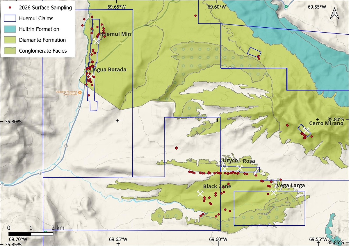 Table 1 Selected samples containing either U 3O 8 above 5,000 ppm or Cu above 2.0%:
Sample ID
Ag (ppm)
Cu (%)
U 3O 8
(ppm)
V 2O 5
(ppm)
Sample ID
Ag (ppm)
Cu (%)
U 3O 8
(ppm)
V 2O 5
(ppm)
4247
95
2.30
183
80
4348
13
4.48
238
68
4257
64
4.04
321
195
4358
12
2.78
189
105
4277
31
0.29
10,577
3,570
4359
10
3.68
93
82
4278
32
1.24
6,450
6,927
4365
<5
8.54
26
198
4290
79
0.84
26,768
16,085
4366
<5
4.33
31
82
4291
105
0.27
24,409
12,621
4372
<5
2.35
29
154
4292
45
0.17
24,174
12,853
4374
5
2.20
74
89
4293
17
0.23
9,905
6,516
4375
5
3.05
71
77
4296
133
2.04
16,922
12,978
4384
<5
2.37
11
79
4297
212
0.42
17,983
9,515
4400
10
2.05
111
54
4298
85
0.23
21,579
13,996
4403
27
3.66
91
86
4319
210
1.62
42,097
22,672
4405
38
4.37
377
91
4325
8
2.08
53
86
4408
21
5.11
284
161
4328
<5
3.39
61
134
4423
17
4.27
31
114
4333
15
2.02
61
68
4424
8
3.11
15
100
4335
62
5.78
164
96
4425
<5
2.20
5
71
4344
<5
3.82
145
80
TORONTO, Oct. 6, 2026 /PRNewswire/ -- Jaguar Uranium Corp. (NYSE-AM: JAGU) ("Jaguar" or the "Company") is pleased to announce an additional high-grade uranium assay from its initial rock sampling program at the Huemul Uranium-Copper-Vanadium (U-Cu-V) Project in Malargüe, Mendoza Province, Argentina. The Company previously reported initial sampling results on July 20, 2026 and August 18, 2026, with the latest assay representing a new over-limit uranium sample received from the program. The sample returned 4.21% U₃O₈ (3.57% U), exceeding the laboratory's upper reporting limit of 25,000 ppm uranium.
The Huemul Project covers more than 27,000 hectares in the Huemul district and includes a past-producing uranium mine. The results of the current sampling program will be used to support ongoing target evaluation as the Company considers the potential for a maiden drill campaign at the Project.
___________________________
1 The sample does not represent a channel width and may not be representative of average grade or continuity.
2 Because sampling was selective and targeted areas of visible mineralization, the results may be biased high and should not be considered representative of grade distribution, continuity or mineralization across the Huemul ProjectOne.
3 The occurrences have not been demonstrated to form a continuous mineralized zone.
Management Commentary
"We are encouraged by this latest high-grade uranium result from Huemul, which provides further evidence of the strength of the uranium system we are seeing at surface. A result of 4.21% U₃O₈ is particularly significant as we continue to advance our understanding of the Project and plan the next steps in our exploration program. These results are helping us refine our exploration priorities and identify the areas with the greatest potential for follow-up work." said Steven Gold, President & Chief Executive Officer.
A District with Documented Historical Production
The Huemul Project is anchored by Argentina's first-ever producing uranium mine, commissioned in 1955 and operated continuously until 1975 by the Comisión Nacional de Energía Atómica (CNEA). Historical records report that approximately 130,000 tonnes of mineralized material, historically described as ore, were processed at the Malargüe plant, with reported average head grades of 0.21% uranium, 2.0% copper and 0.11% vanadium (source: Guillermo Rojas, 1999. Distrito Uranìfero Pampa Amarilla, Mendoza. En Recursos Minerales de la Republica Argentina. Pag.1135-1140). The Company has not independently verified the historical production records or historical head-grade information, and such information should not be interpreted as current exploration results, a mineral resource estimate, a mineral reserve estimate or evidence of current economic viability. The historical information is considered relevant because it indicates the presence of uranium-copper-vanadium mineralization within the Project area. 4
The project hosts uranium-copper-vanadium mineralization in a classic sandstone-hosted deposit setting. The broader Malargüe Mining District remains largely untested by modern exploration methods. Based on the presence of a former producing mine, historical exploration data, and the extent of the Company's land package, management believes the project warrants further systematic exploration.
____________________________
4 Additional work would be required to verify the historical information and determine its relevance to current exploration results.
Sampling Program and QA/QC
Jaguar conducted targeted sampling that included outcrop, subcrop, rock chip composite, channel and float samples, across areas of visible surface mineralization. Field observations were generally consistent with the presence of mineralization described in historical reports, particularly around the former Huemul mine, as described previously here. Samples were collected from eight target areas, namely, Huemul Mine, Agua Botada, Uryco, Rosa, Vega Larga, Black Zone, Cerro Mirano and Lucy (Figure 1).
Channel samples were collected over intervals ranging from 50 cm to 280 cm. All samples were packaged and sealed at the project site by Jaguar geologist and transported to ALS in Mendoza, Argentina for analysis using sodium peroxide decomposition method ME-MS89L™. ALS Mendoza is a full-service laboratory and is ISO/IEC 17025 accredited sample preparation and geochemical analysis. ALS Mendoza is independent of Jaguar.
Jaguar included 6 Blanks and 6 Duplicates as part of the sample submission (200 samples in total) for QA/QC assessment. Blank material performed satisfactorily. Two duplicate samples did not compare well and were subsequently re-analysed. The re-analysis confirmed the original assay values for those samples. The QP has reviewed the QA/QC results and affirms that the assay results suitable for disclosure as Exploration Results.
Since the sampling of visible mineralization is selective by nature, the exploration results disclosed in this news release are potentially biased and do not establish the extent and continuity of grade, tonnage, economic significance, mineral resources or mineral reserves of the Huemul Project.
Huemul Mine / Agua Botada Trend
The Huemul Mine / Agua Botada Trend represents a predominantly uranium-vanadium mineralized zone. Mineralization is hosted in the Diamante Formation sandstones, conglomerates, shales and volcaniclastics striking north-south and dipping 20-25° to the west in the north and becoming flat lying to the south. Recent sampling results appear to show the dominance of U over Cu in this area (Figure 3).
Uryco-Rosa, Black Zone and Vega Larga Trend
The Cerro Mirano, Uryco-Rosa, Black Zone and Vega Larga areas are dominated by Cu-U-V±Ag mineralization. Mapping, rock sampling and gamma surveying have delineated the Uryco-Rosa, Black Zone and Vega Larga target areas, with apparent strike lengths of approximately 2,200 m, 1,300 m and 2,300 m, respectively, hosted along conglomerate and sandstone horizons of the Diamante Formation that collectively define a greater than 4 km corridor of mineralized occurrences. The Cerro Mirano mineralized zone is related to the intrusion of andesitic dikes and is approximately 300 m long. Recent sampling results appear to show the dominance of Cu over U in this area (Figure 3).
Since the sampling of visible mineralization is selective by nature, the exploration results disclosed in this news release are potentially biased and do not establish the extent and continuity of grade, tonnage, economic significance, mineral resources or mineral reserves of the Huemul Project.
Data Verification
The QP's review of the sampling, analytical and QA/QC information disclosed in this news release was limited to a review of information provided by the Company and its consultants, including sample locations, sample descriptions, analytical certificates, analytical methods and QA/QC results. The QP has not completed a current site visit to the Huemul Project and has not independently observed or physically verified the sampling procedures, sample locations, sample security or chain-of-custody procedures. The QP has not independently verified the historical production, historical grade or historical exploration information referenced in this news release. The QP's review is subject to the limitations described herein, including the selective nature of the samples.
Over-limit samples for copper (indicated as >25000) were re-analysed by ALS using 4 acid digest and ICP finish (ME-OG62™). One over-limit sample for uranium (indicated as >25000) was re-analysed using XRF for base metal ores by fusion (ME-XRF15b™). Duplicate re-analysis confirmed the original assay results that were received and indicates a potential sample swap, either during project preparation, or at the laboratory. In the opinion of the QP, these issues are not material at this stage of the project but will need closer attention during further work phases.
Cautionary Note
The Huemul Project is an exploration-stage property. No mineral resource or mineral reserve estimate has been prepared for the Huemul Project under National Instrument 43-101 — Standards of Disclosure for Mineral Projects ("NI 43-101") or Subpart 1300 of Regulation S-K. The surface sampling results disclosed in this news release are Exploration Results only and should not be interpreted as establishing the presence of mineral resources or mineral reserves. Rock chip and channel samples are selective by nature and may not be representative of mineralization across the property.
Historical production, grade and exploration information referenced in this news release is historical in nature and has not been independently verified by the Company or by a Qualified Person under NI 43-101 or Subpart 1300 of Regulation S-K. The Company is not treating this information as current mineral resources, mineral reserves, or current exploration results. The information is considered relevant because it indicates the presence of uranium-copper-vanadium mineralization on the property, but it should not be relied upon until confirmed by additional exploration work.
Qualified Person
The scientific and technical information contained in this news release has been reviewed and approved by George van der Walt, Pr.Sci.Nat., an independent Principal Consultant with The MSA Group (Pty) Ltd., who is a Qualified Person under NI 43-101 and Subpart 1300 of Regulation S-K. Mr. van der Walt has reviewed the sampling, analytical and QA/QC information disclosed in this news release on the basis of information provided by the Company and its consultants and has approved the technical disclosure in the form and context in which it appears. Mr. van der Walt has not completed a current site visit to the Huemul Project and has not independently observed or physically verified the sampling procedures or sample chain of custody.
About Jaguar Uranium
Jaguar Uranium Corp. is a South America-focused uranium exploration company advancing a portfolio of prospective brownfield projects across Argentina and Colombia. In Argentina, Jaguar is advancing the Laguna Salada Project in Chubut Province and the historic Huemul uranium mine in Mendoza Province. Anchored by a former producing mine, a historic uranium district and exploration projects supported by historical drilling, the Company is focused on advancing and expanding uranium opportunities across the region. The Company's Berlin Project in Caldas Province, Colombia is a district-scale, sedimentary-hosted polymetallic system historically reported to host uranium alongside rare earth elements, vanadium, nickel, phosphate, molybdenum, rhenium and zinc. Jaguar completed a $25 million initial public offering on NYSE American in February 2026 and is led by an experienced team with backgrounds in exploration, permitting, project development and mining finance in South America.
www.jaguaruranium.com
Forward Looking Statements
This news release contains "forward-looking statements" within the meaning of applicable U.S. and Canadian securities laws. Forward-looking statements are statements that are not historical facts and include, without limitation, statements regarding: the interpretation of exploration results; the potential extent, continuity, and significance of observed mineralization; the identification of prospective target areas; the potential for discovery; planned or future exploration programs; and the Company's expectations regarding the Huemul Project and the broader Malargüe district.
Forward-looking statements are based on a number of material assumptions, including, but not limited to: the accuracy of historical data; the reliability of sampling and field observations; the continuity of mineralization observed at surface; the availability of financing and personnel; the availability of equipment, laboratory capacity, property access and required permits; and the Company's ability to execute its exploration plans as currently contemplated.
Forward-looking statements are subject to known and unknown risks, uncertainties and other factors that may cause actual results to differ materially from those expressed or implied by such statements. These risks and uncertainties include, among others: risks relating to the interpretation of exploration results; risks that duplicate-sample reanalysis or additional QA/QC review may affect the interpretation of results; the possibility that mineralization is not continuous or of economic grade; risks associated with early-stage exploration properties; the selective nature of rock chip, channel, composite, select and mine-dump samples; reliance on historical data that may be incomplete or inaccurate; commodity price volatility; permitting and regulatory risks; operational and technical risks; and general economic, market and industry conditions.
Forward-looking statements speak only as of the date of this news release. Except as required by applicable securities laws, the Company undertakes no obligation to update or revise any forward-looking statements to reflect events or circumstances after the date of this release or to reflect the occurrence of unanticipated events.
APPENDIX 1: Full tabulation of final sample assay results
Sample ID
Easting
Northing
Sample Type
Channel
Length
(cm)
Channel
Orientation
(°)
Ag (ppm)
Cu (%)
U 3O 8
(ppm)
V 2O 5
(ppm)
4226
2440636
6042968
Outcrop Chip
<5
0.002
4
107
4227
2440703
6042691
Subcrop Channel
160
250
<5
0.002
1
129
4228
2440703
6042691
Subcrop Channel
80
250
<5
0.003
2
316
4229
2440718
6042793
Outcrop Channel
100
<5
<0.002
3
155
4230
2439837
6043204
Outcrop Channel
140
250
<5
<0.002
2
18
4231
2439756
6042929
Outcrop Channel
120
0
<5
<0.002
2
86
4232
2440192
6043308
Outcrop Composite
<5
<0.002
5
25
4233
2440183
6042783
Outcrop Channel
200
270
<5
<0.002
2
62
4234
2440176
6042580
Outcrop Channel
120
260
<5
0.002
2
64
4235
2440428
6042411
Outcrop Composite
<5
<0.002
2
68
4236
2440446
6042469
Outcrop Channel
110
280
<5
<0.002
1
43
4237
2440493
6042537
Outcrop Composite
<5
<0.002
2
109
4238
2440436
6042855
Outcrop Composite
<5
<0.002
3
89
4239
2440759
6042423
Outcrop Channel
80
270
<5
0.003
1
291
4240
2440656
6042568
Outcrop Composite
<5
0.002
2
77
4241
2440743
6042595
Outcrop Channel
80
270
<5
0.003
1
327
4242
2440196
6041287
Mine Dump
19
0.135
101
52
4243
2440196
6041287
Mine Dump
11
0.268
126
48
4244
2440210
6041262
Mine Dump
150
280
<5
0.122
69
71
4245
2440205
6041268
Mine Dump
200
15
106
0.336
1,562
77
4246
2440228
6041289
Mine Dump
43
0.816
2,465
80
4247
2440310
6041673
Subcrop Composite
95
2.300
183
80
4248
2440323
6041677
Mine Dump
13
1.685
123
68
4249
2440247
6041822
Outcrop Composite
<5
0.009
5
148
4250
2440244
6041754
Outcrop Composite
<5
0.004
2
96
4251
2440179
6041612
Outcrop Composite
<5
0.005
3
155
4252
2440208
6041110
Mine Dump
15
0.073
131
89
4253
2440247
6041081
Outcrop Channel
120
280
<5
0.002
5
64
4254
2440247
6041081
Outcrop Channel
80
280
<5
0.002
8
134
4255
2440240
6041074
Outcrop Channel
60
270
11
0.971
324
262
4257
2440240
6041074
Outcrop Channel
110
270
64
4.040
321
195
4259
2440226
6041078
Outcrop Channel
70
300
<5
0.009
18
118
4260
2440226
6041078
Outcrop Channel
80
300
<5
0.009
11
86
4261
2440233
6041081
Outcrop Channel
100
300
<5
0.028
36
59
4262
2440214
6041079
Outcrop Composite
<5
0.005
7
146
4263
2440214
6041079
Outcrop Channel
80
280
<5
0.006
9
102
4264
2440202
6041075
Outcrop Channel
120
280
<5
0.002
14
87
4265
2440202
6041075
Outcrop Channel
100
280
<5
0.014
8
55
4266
2440197
6041068
Outcrop Channel
90
280
5
0.140
76
73
4267
2440197
6041068
Outcrop Channel
50
270
<5
0.013
6
186
4268
2440197
6041068
Outcrop Channel
70
270
<5
0.005
5
73
4269
2440104
6041042
Outcrop Composite
<5
0.002
4
100
4270
2440073
6040983
Outcrop Channel
120
280
<5
0.002
3
120
4271
2440107
6040952
Outcrop Composite
<5
0.002
2
93
4272
2439953
6040953
Outcrop Channel
120
<5
<0.002
6
50
4273
2439991
6040998
Outcrop Composite
<5
<0.002
6
84
4274
2440019
6040663
Mine Dump
150
14
0.418
2,630
812
4275
2440032
6040624
Mine Dump
180
14
0.275
237
261
4276
2439981
6040684
Mine Dump
170
16
0.692
357
225
4277
2439977
6040682
Mine Dump
31
0.294
10,577
3,570
4278
2439970
6040697
Mine Dump
32
1.235
6,450
6,927
4279
2440041
6040718
Outcrop Composite
<5
0.010
68
118
4280
2440059
6040708
Outcrop Channel
230
30
<5
0.058
53
221
4281
2440061
6040715
Outcrop Channel
200
30
17
0.820
50
177
4282
2440060
6040718
Outcrop Channel
200
0
28
1.145
52
198
Sample ID
Easting
Northing
Sample Type
Channel
Length
(cm)
Channel
Orientation
(°)
Ag (ppm)
Cu (%)
U 3O 8
(ppm)
V 2O 5
(ppm)
4283
2440063
6040718
Outcrop Channel
200
0
30
0.815
87
746
4284
2440064
6040722
Outcrop Channel
200
0
708
1.460
4,964
4,963
4285
2440062
6040724
Outcrop Channel
200
0
68
1.810
180
666
4288
2440062
6040720
Outcrop Channel
200
0
33
0.686
65
204
4289
2440062
6040726
Outcrop Channel
200
0
24
0.925
107
209
4290
2440061
6040729
Outcrop Channel
200
0
79
0.839
26,768
16,085
4291
2440061
6040730
Outcrop Channel
200
0
105
0.272
24,409
12,621
4292
2440060
6040732
Outcrop Channel
200
0
45
0.171
24,174
12,853
4293
2440061
6040735
Outcrop Channel
200
0
17
0.229
9,905
6,516
4294
2440063
6040735
Outcrop Channel
200
0
12
0.305
651
1,883
4295
2440063
6040739
Outcrop Channel
200
0
5
0.247
137
1,312
4296
2440061
6040742
Outcrop Channel
200
0
133
2.040
16,922
12,978
4297
2440062
6040744
Outcrop Channel
200
0
212
0.417
17,983
9,515
4298
2440066
6040748
Outcrop Channel
180
90
85
0.228
21,579
13,996
4299
2440086
6040746
Subcrop Composite
5
0.077
195
653
4300
2439969
6040765
Mine Dump
150
90
6
0.094
136
271
4301
2440149
6040367
Mine Dump
200
60
8
0.075
200
130
4302
2440127
6040380
Not recorded
25
1.240
986
578
4303
2440105
6040400
Mine Dump
200
60
9
0.194
657
139
4304
2440089
6040433
Mine Dump
200
0
18
0.808
771
528
4305
2440067
6040431
Mine Dump
200
0
<5
0.032
68
186
4306
2440050
6040415
Mine Dump
200
0
13
0.332
1,374
630
4307
2440048
6040411
Mine Dump
200
0
5
0.038
74
184
4308
2440026
6040427
Mine Dump
200
130
9
0.368
2,258
2,499
4309
2440102
6040525
Mine Dump
62
0.474
3,396
275
4310
2440059
6040485
Mine Dump
200
120
<5
0.034
77
154
4311
2440049
6040444
Mine Dump
200
290
<5
0.057
63
118
4312
2440006
6040439
Mine Dump
200
11
0.230
364
298
4313
2440015
6040444
Mine Dump
25
1.025
1,048
262
4314
2440023
6040479
Mine Dump
200
110
<5
0.011
25
111
4315
2440039
6040509
Mine Dump
200
170
<5
0.068
110
132
4318
2440079
6040521
Mine Dump
200
150
<5
0.025
31
154
4319 (8)
2440065
6040738
Outcrop Composite
210
1.620
42,097
22,672
4320
2440241
6040636
Subcrop Composite
<5
0.008
110
121
4321
2440293
6040594
Outcrop Channel
280
90
<5
0.008
192
150
4322
2440203
6040235
Outcrop Composite
<5
0.039
21
71
4323
2439940
6040265
Outcrop Composite
<5
0.008
11
86
4324
2440102
6040482
Mine Dump
200
200
7
0.131
285
561
4325
2440050
6039769
Outcrop Composite
8
2.080
53
86
4326
2445263
6035159
Outcrop Composite
<5
0.006
5
70
4327
2445270
6035090
Outcrop Composite
26.0
0.026
37
175
4328
2445247
6035007
Outcrop Composite
<5
3.390
61
134
4329
2445250
6035005
Outcrop Composite
<5
0.049
13
80
4330
2448707
6035962
Outcrop Composite
35
0.449
64
84
4331
2448711
6035963
Outcrop Composite
17
0.140
44
64
4332
2444003
6037410
Mine Dump
6
0.793
624
484
4333
2444000
6037374
Outcrop Composite
15
2.020
61
68
4334
2449818
6037854
Outcrop Select
38
1.640
166
91
4335
2449740
6037990
Outcrop Composite
62
5.780
164
96
4336
2449690
6038031
Mine Dump
18
1.750
198
182
4337
2448998
6038428
Outcrop Channel
120
270
372
1.435
120
673
4338
2449015
6038412
Outcrop Channel
110
7
0.759
7
82
4339
2444807
6036267
Float Select
<5
0.007
6
59
4340
2444815
6036263
Subcrop Select
635
0.157
1,987
1,794
4341
2445076
6036272
Outcrop Channel
150
180
<5
1.460
73
62
4342
2445080
6036264
Outcrop Channel
70
180
<5
0.310
35
132
4343
2445083
6036264
Outcrop Channel
100
180
<5
0.013
5
62
4344
2445090
6036269
Mine Dump
200
0
<5
3.820
145
80
Sample ID
Easting
Northing
Sample Type
Channel
Length
(cm)
Channel
Orientation
(°)
Ag (ppm)
Cu (%)
U 3O 8
(ppm)
V 2O 5
(ppm)
4346
2445181
6036252
Outcrop Channel
100
180
<5
0.433
5
73
4347
2445249
6036248
Subcrop Channel
200
240
<5
1.175
4
52
4348
2446002
6036256
Outcrop Channel
160
13
4.480
238
68
4350
2445961
6036251
Outcrop Composite
8
1.050
46
59
4351
2445917
6036262
Outcrop Channel
180
110
<5
0.976
26
57
4352
2445852
6036280
Outcrop Composite
<5
0.722
7
73
4353
2445726
6036259
Outcrop Channel
100
180
<5
0.139
37
180
4354
2445723
6036260
Outcrop Channel
150
180
<5
0.362
12
57
4355
2445720
6036263
Outcrop Channel
200
180
<5
0.533
8
59
4356
2445523
6036252
Outcrop Channel
130
240
<5
0.383
4
45
4357
2445445
6036254
Outcrop Composite
<5
0.734
5
48
4358
2445458
6036301
Outcrop Channel
180
180
12
2.780
189
105
4359
2446453
6036262
Outcrop Composite
10
3.680
93
82
4360
2446565
6036305
Outcrop Channel
120
180
9
0.926
68
77
4361
2446544
6036304
Outcrop Channel
110
180
19
2.000
329
104
4362
2446519
6036288
Outcrop Channel
170
180
7
1.595
92
62
4363
2446349
6036247
Mine Dump
200
120
31
0.998
157
95
4364
2446311
6036238
Outcrop Composite
<5
0.507
21
52
4365
2446201
6036261
Outcrop Channel
100
<5
8.540
26
198
4366
2447091
6036238
Outcrop Channel
150
180
<5
4.330
31
82
4367
2447078
6036240
Outcrop Channel
150
180
<5
0.831
30
84
4368
2446759
6036239
Outcrop Composite
<5
0.601
7
45
4369
2446639
6036267
Outcrop Composite
<5
0.836
21
57
4370
2446798
6036260
Outcrop Composite
<5
0.046
27
179
4371
2447195
6036214
Outcrop Composite
<5
0.161
6
62
4372
2447903
6035889
Outcrop Channel
120
120
<5
2.350
29
154
4373
2447824
6035915
Outcrop Composite
<5
0.339
4
86
4374
2448267
6035877
Subcrop Select
5
2.200
74
89
4375
2448287
6035870
Subcrop Select
5
3.050
71
77
4378
2446352
6035774
Outcrop Channel
150
50
<5
0.559
35
100
4379
2446347
6035763
Outcrop Channel
30
<5
0.466
5
84
4380
2446126
6035620
Outcrop Composite
<5
0.593
26
82
4381
2446032
6035350
Outcrop Composite
<5
0.004
35
55
4382
2446146
6035400
Outcrop Channel
120
40
<5
0.038
22
96
4383
2445480
6035148
Outcrop Composite
105
1.325
70
200
4384
2445490
6035156
Outcrop Composite
<5
2.370
11
79
4385
2445774
6035357
Outcrop Composite
24
0.217
69
168
4386
2445770
6035347
Float Select
8
0.569
73
75
4387
2445772
6035252
Outcrop Channel
60
240
77
0.017
284
59
4388
2445567
6034864
Outcrop Composite
13
0.065
43
120
4389
2445522
6034904
Outcrop Channel
160
20
<5
0.007
38
84
4390
2445517
6034897
Outcrop Channel
200
10
<5
0.003
30
82
4391
2447591
6036155
Subcrop Composite
7
0.213
53
61
4392
2448224
6035655
Float Select
<5
0.096
5
52
4393
2448187
6035678
Subcrop Select
<5
0.081
10
68
4394
2448134
6035690
Float Select
39
0.423
42
116
4395
2448135
6035316
Outcrop Select
26
0.569
77
50
4396
2444590
6036319
Outcrop Channel
170
180
62
1.590
65
146
4397
2444667
6036313
Outcrop Channel
80
180
<5
0.701
26
52
4398
2444716
6036295
Outcrop Channel
170
180
<5
0.880
22
71
4399
2444580
6036321
Outcrop Channel
170
180
205
1.355
855
268
4400
2450109
6037912
Outcrop Channel
150
140
10
2.050
111
54
4401
2449781
6037862
Outcrop Select
15
1.160
130
87
4402
2449771
6037840
Outcrop Select
23
1.055
120
87
4403
2449827
6037945
Float Select
27
3.660
91
86
4404
2449782
6037967
Outcrop Channel
100
180
9
1.920
116
80
4405
2449780
6037962
Mine Dump
200
150
38
4.370
377
91
4408
2449651
6038044
Outcrop Composite
21
5.110
284
161
Sample ID
Easting
Northing
Sample Type
Channel
Length
(cm)
Channel
Orientation
(°)
Ag (ppm)
Cu (%)
U 3O 8
(ppm)
V 2O 5
(ppm)
4409
2449667
6038061
Float Select
5
1.775
57
114
4410
2446412
6034546
Outcrop Select
<5
0.129
69
66
4411
2446202
6034613
Outcrop Channel
100
200
<5
0.075
310
80
4412
2446202
6034613
Outcrop Channel
120
200
<5
0.015
116
66
4413
2446202
6034613
Outcrop Select
<5
0.021
17
71
4414
2445908
6034400
Outcrop Channel
170
310
<5
0.098
276
68
4415
2445908
6034399
Outcrop Channel
120
310
<5
0.005
23
91
4416
2445785
6034305
Outcrop Channel
120
90
<5
0.007
28
96
4417
2445791
6034307
Outcrop Channel
110
0
<5
0.006
15
57
4418
2445204
6034412
Outcrop Channel
160
160
<5
0.393
4
102
4419
2445209
6034419
Outcrop Channel
140
0
<5
0.069
6
50
4420
2445117
6034346
Subcrop Composite
<5
0.367
2
93
4421
2445091
6034329
Float Select
36
1.935
125
114
4422
2445090
6034328
Subcrop Channel
100
30
<5
0.135
2
55
4423
2447696
6041535
Outcrop Composite
17
4.270
31
114
4424
2447729
6041426
Outcrop Composite
8
3.110
15
100
4425
2444862
6043361
Outcrop Composite
<5
2.200
5
71
Notes:
1)
Coordinates Projection: Campo Inchauspe / Argentina 2 (ellipsoid: International 1924)
2)
ppm = g/t
3)
10,000 ppm = 1.0%
4)
U converted to U 3O 8 using the conversion factor U x 1.1792 and V converted to V 2O 5 using the conversion factor V x 1.7852.
5)
The primary ALS analytical method was "ME-MS89L™", which is a sodium peroxide decomposition for complete recovery of lithium, rare earths, and associated trace elements.
6)
"<" indicates below lower limit of detection, ">" indicates above upper limit of detection.
7)
Over-limit samples for Cu (>25,000) were analysed using the ALS method "ME-OG62™", which is uses four acid digestion to break down most silicates and all but the most resistive minerals.
8)
Over-limit sample 4319, originally reported as >25,000 ppm U, was reanalysed using the ALS method "U-XRF15b™", which is an ore grade XRF assay of a sample prepared by fusion with an oxidizing flux.
SOURCE Jaguar Uranium